Route Editor

| Guide | ♦ | 3 Triplogs | 0 Topics |
details | drive | no permit | forecast | route |
stats |
photos | triplogs | topics | location |
| 106 | 3 | 0 |
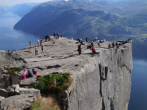
Needs no Introduction by rvcarter  Introduction(even though none is needed) There may be no more dramatic and signature Norway views than the ones of and from Preiskestolen, known in the English-speaking world as Pulpit Rock. It’s a small flat plateau called in olden times Hyvlatanna (planed tooth), likely formed as the glaciers started melting in Norway some 10,000 years ago. The cleaving has left a precariously perched rock formation above the Lysefjord. Someday this remnant formation will fall also, but in the meantime, it is a must-do hike for anyone visiting Norway. The best part is that it’s not that hard of a hike. Hike Get ready to hike with lots of your fellow mankind; this is a popular hike even in the off months (we visited in mid-September). I can’t imagine what it’s like in summer. Starting at the parking lot, the hike is alternatively easy walking, mild scrambles up bouldery paths, and short periods crossing board walkways in the marshy areas. The scrambling may be on the difficult side for some people, but there is nothing that a reasonably fit person can’t do. Just start early and take your time. We took it easy, stopped lots of times, and it still only took about 4 hours for the round trip. The trail is well marked and has several resting points along the way. There is a huge international presence, with people from all over the world. Good views from nearly anyplace once you reach the ridge and turn back along the cliff for the last 1000 feet or so. Lots of shade along the way.
The cruise ships and other boats in the fjord below look incredibly small. You feel slightly sorry for the cruise ship folks who see only a small (from their distance) rock jutting out over the fjord. It is much, much better to see it from above, up close and personal. This is an incredibly impressive natural treasure of Norway, and you owe it to yourself to see it. There is an alternative return from the Rock called the Hill Trail on most maps which affords additional views, making the trail more of a “lasso” shape. We didn’t take it back but it appears to involve more scrambling; I saw no one taking it in the half-hour we were on the Rock. See Chumley’s track if you’re interested in this option. You can see people on the Rock on Google Earth. Some Trip Planning Tips First, this is not a winter hike, and it would be much harder when the rock is wet. Summers months are likely to mean crushing hoards with some in flip flops but not enough water. August is when Europeans take vacations. So that leaves September and maybe part of October. Don’t know about spring. Second, take plenty of money. Norway has to be one of the most expensive places to visit on earth. They have a very high tax rate on everything (e.g., 25% on paper towels, one beer is over $4.00 in the grocery store, 3x that in a bar, gasoline is nearly $6 per gallon). They are not on the Euro despite being in the EU, but their currency (the Norwegian Krone, or NOK) is “pegged” to the Euro. Third, if you imbibe, make sure you max out your personal quota at the Duty Free store at the airport. Passengers arriving at Oslo walk through the stores to reach the baggage carousel. I paid $42 for ¾ liter of bourbon at the state-owned Vinmonopolet (read monopoly) spirits outlet in downtown Stavanger. Fourth, study Norway’s outstanding and informative website. It covers everything from soup to nuts about visiting Norway and has an interactive map. Fifth, download Google Translate to your smartphone. Another very useful app is Maps.me, which works via satellite links, even when the phone is in airplane mode. Additional Resources •Free (donations accepted) digital maps suitable for use with Garmin Basecamp and download to Garmin GPS: http://www.frikart.no/garmin/velgkart.html. Download “Topo Summer” for the hiking and trail info. Check out the Official Route and Triplogs. Leave No Trace and +Add a Triplog after your hike to support this local community. | |||||||||||||||||||||||||||||||||||||||||||||||||||||||||||||||||||||||||||||||||||||||||